
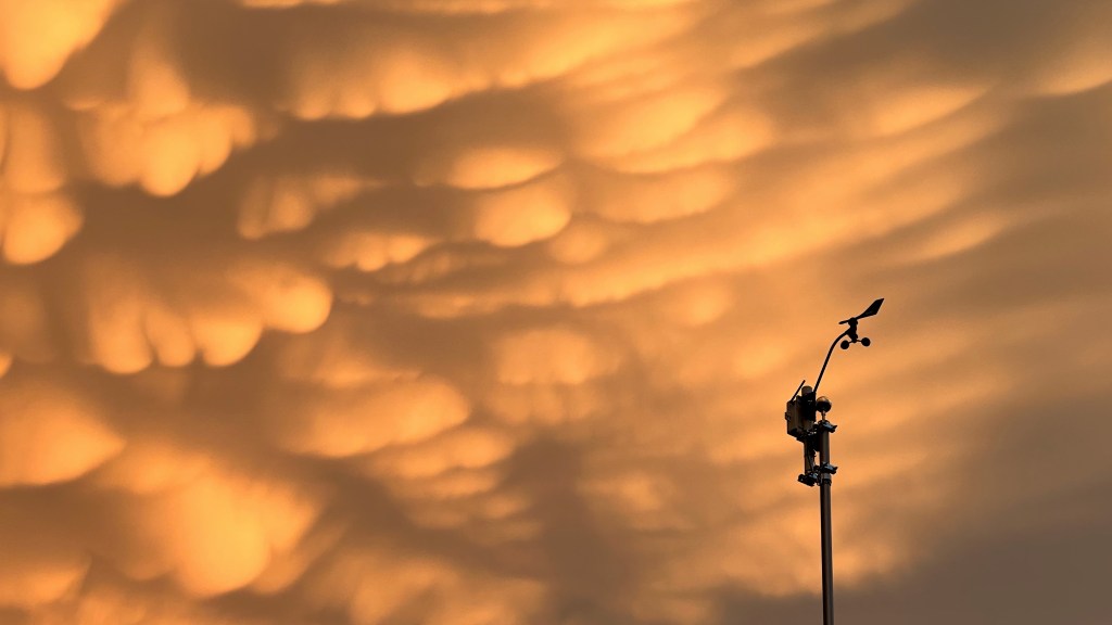
It is unusual for our area to see discrete thunderstorms — individual storms visible against otherwise clear skies — so we miss out on some thrilling sights. The anvil or thunderhead of a strong storm usually happens above a lower cloud layer in our region, hidden from those of us who appreciate such things. On July 20, 2022 a severe thunderstorm rolled right overhead. I’ve rarely, if ever, heard so many cracks of thunder so close by. I was indoors, did not see the mammoth bolts directly above my roof, and was actually getting concerned the house, or my tall flagpole, would be hit. I was close to being afraid of the lightning, and that’s very unusual! The storm passed, as storms do, and I took a peek through a window. To the west the sky was clearing as the clean edge of the thunderstorm moved east but then the thrill: mammatus clouds! Technically, mammatus are not rare phenomena, often hanging from the anvils of thunderstorms, but we rarely see them here for the reasons given above — we rarely see the anvils. The sky was full of them! I grabbed my iPhone (nearest camera) and hurried outside. Though I feared it would end quickly, the display went on til after dark. Here are a few views…


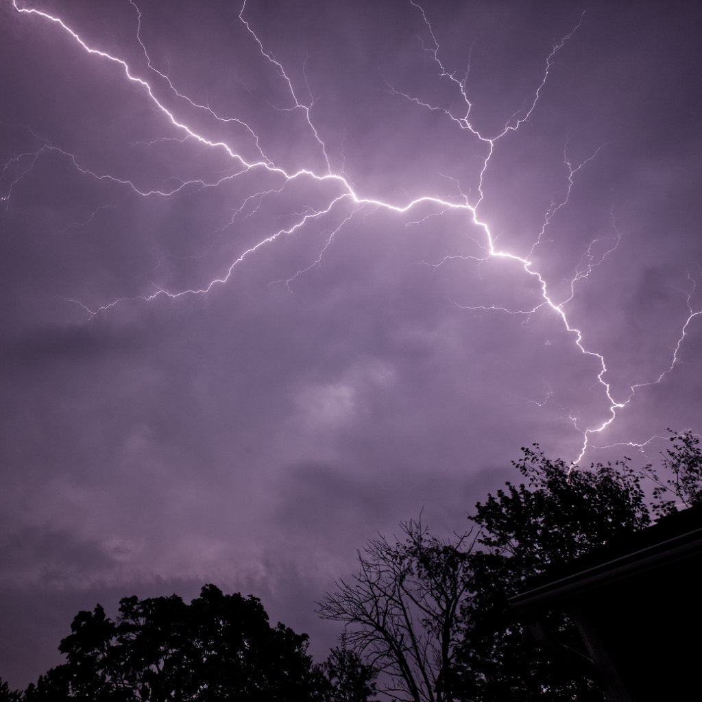
I stayed up late, anticipating the arrival of a powerful storm system the night of June 13. The MCS (mesoscale convective system) tracked to the south of its predicted path, leaving me at the northern end of storm activity. I thought I was out of luck but saw some lightning and decided to try for some photos. My persistence and resulting sleep deprivation was rewarded. I witnessed several impressive displays of “anvil crawler” lightning — cloud-to-cloud discharges along the cloud base — but missed a couple. At midnight, however, this amazing crawler filled my visual field and the view from the camera. The strong horizontal bolts steal the show but look closer. Even in this reduced-resolution web version of the photo, streaks of lightning reach up and down across the bottom of the storm cloud. I remember seeing the motion of the light, almost like an advertising sign, luminescence racing along those fine lines. The MCS blasted across our region, downing trees and utility poles along its path. Here, the storm passed dropping only a little rain with virtually no wind, allowing me to make this capture (a single exposure). The local newspaper surprised me by using the image — full-frame, in color — huge on their front page! It’s hard for newspapers to hold the finest details in print but the e-version looks pretty good.

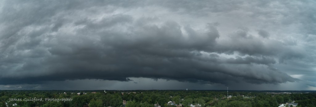
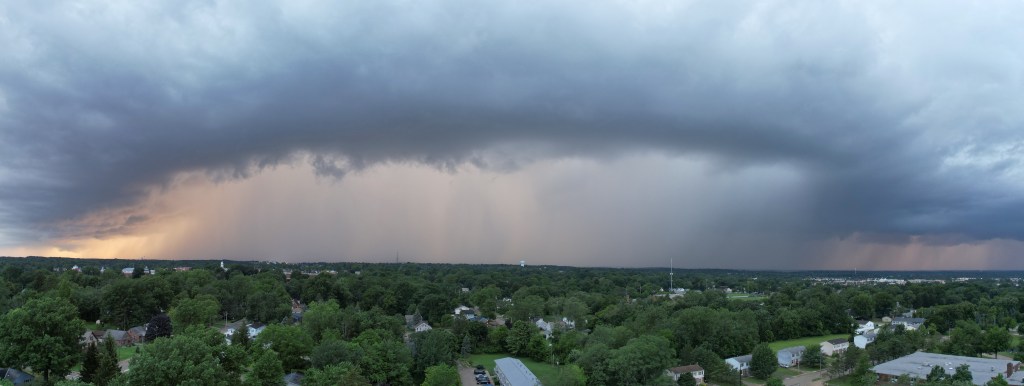
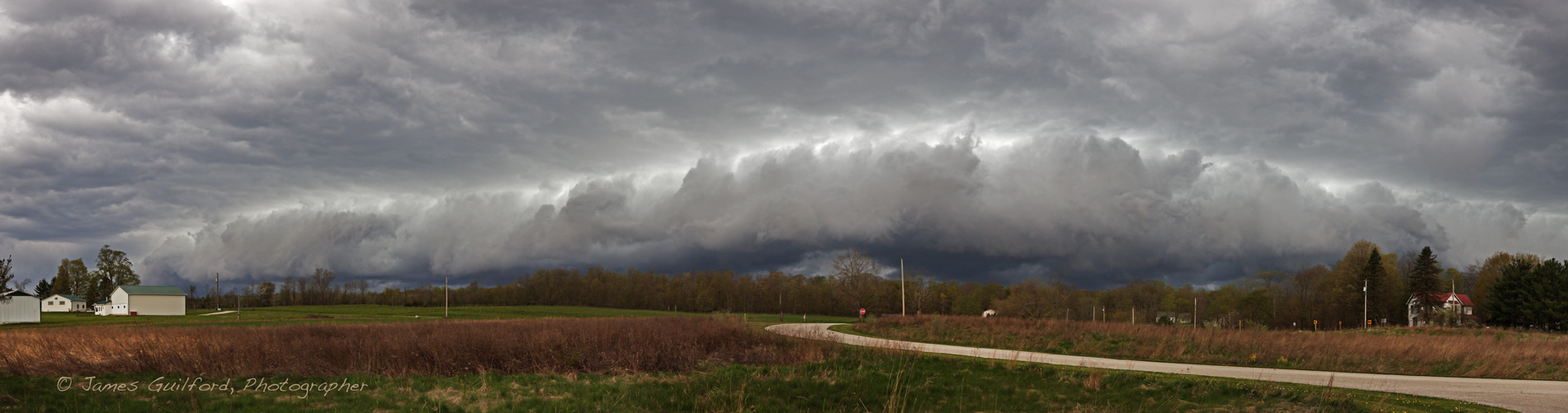
I was able to record the approach of a massive mesoscale convective system (MCS) with its shelf cloud early in the afternoon of August 25 — this panorama I assembled shows most of it. I posted a panning video I shot of the storm and it was discovered by a producer at Accuweather. The cable weather channel requested permission to use the “footage” on-air but I denied the request … I feared their use of my drone video, myself not yet a certified professional drone pilot, would violate FAA regulations. I was later told by a flight instructor that I could have granted permission, even sold the video to a willing buyer, since it was created for recreation and not on assignment or with the intent of commercial use. I still sigh thinking about that one. Mebbie next time!
By the way, I have a lot of experience with this type of weather phenomenon and was even checking radar as the storm approached so I knew when to land to avoid rain and strong winds.
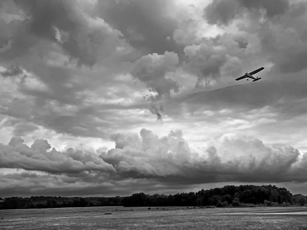
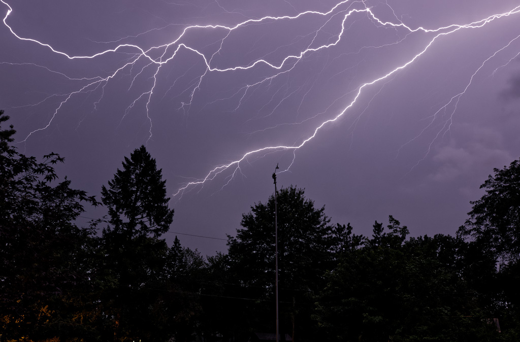
A line of thunderstorms was bearing down on our area the night of July 24 and it looked like it might be interesting — it has been a while since I’ve made any lightning pictures. The storm progressed slowly from Southeastern Michigan and Northwest Ohio and across Lake Erie finally beginning its arrival here around midnight. As the storm overran the area, I watched it for lightning potential. Ducking outside and looking up at one point, I was treated to a beautiful “anvil crawler” display nearly overhead!
I rushed to my office and quickly assembled my gear: Canon EOS 6D Mk. 2, wide-angle lens, and tripod. First to the northern side of the house. After some waiting and a couple of “teasers” the storm let loose a magnificent crawler — brilliant lightning crossing the cloud bottoms, branching off to the sides. Turns out, that was the shot of the night though I didn’t know it at the time since I was unable to preview my images. Light rain began to fall and with not enough shelter, I moved to the south side of the house.
It took a while for the storm to progress southward enough for me to see the dwindling cloud-to-cloud lightning flashes but they eventually came. I spent maybe 90 minutes watching the storm, aiming the camera, waiting for the automatic trigger to capture the ephemeral brilliance. Thunder, this night, rolled across the dark countryside for many seconds after each flash before fading away — something I’ve not experienced in quite some time. It was lovely. My sheltered spot on the south side kept camera, lens, and photographer dry throughout, which isn’t always the case. Rain prevented me from aiming the camera as high as I’d have liked. Just a few drops on the camera lens, combined with a bright lightning flash, produces an unusable image.

The storm petered out so, sometime around 1:45 a.m. I went back indoors, and reviewed the images via the camera’s display. Yes! Beautiful stuff! Editing the photos after sleeping for a few hours was the highlight of my Sunday morning.
In future I really need to find a sheltered place, or at least a place where I can park and shoot from my car at night, a spot that has an open view of the countryside and/or town. In the mean time, results from the Saturday night storm were worth the sleep deprivation.

It has been a fairly quiet (visually) storm season for me this year but there has been some drama. Here are several shots, from two storms, that took place in July.
Views of the July 7th’s approaching storm: the most active portion was behind me producing low rumbles of distant thunder. Except for light, cooling gusts of wind and these beautiful clouds, nothing remarkable happened where I stood. Not even a drop of rain.


A Stormy Landscape. A large and dramatic shelf cloud approaches over rural Medina County, Ohio. Now possibly my favorite shelf cloud photograph, it’s an image made using my Apple iPhone.
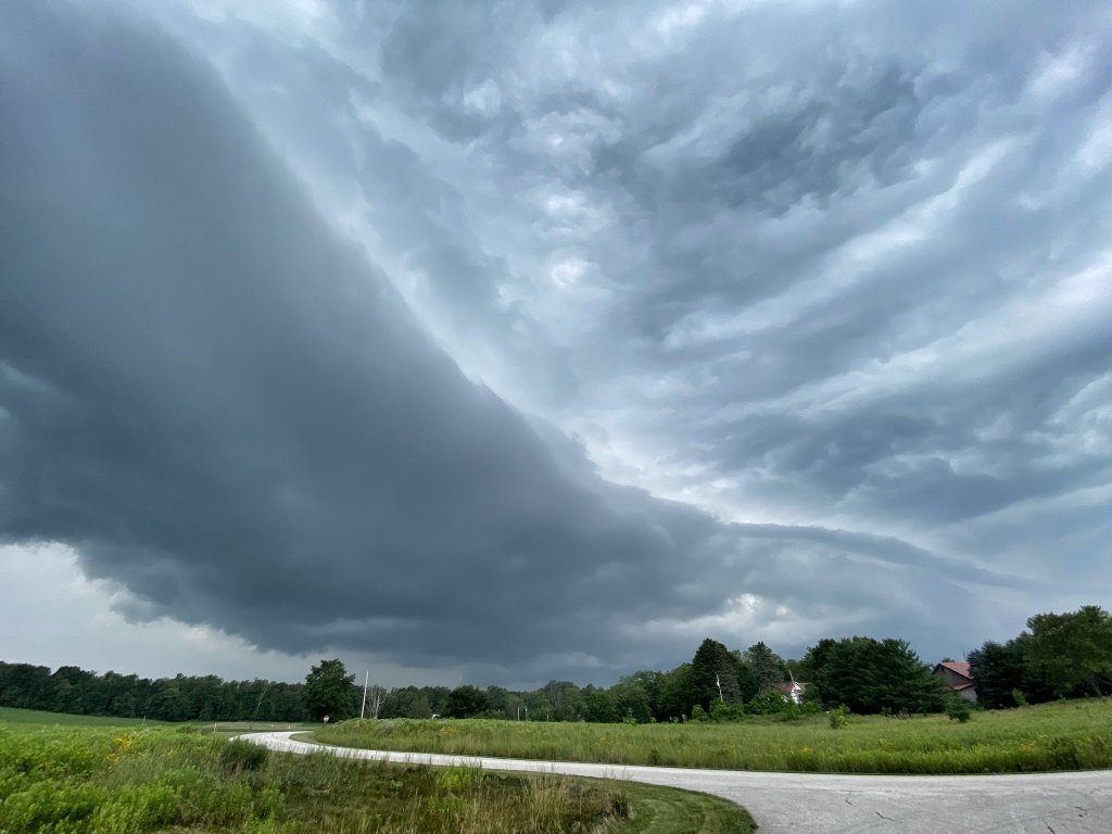
After a long period without rain, Friday saw heavy rains and thunderstorms across the region. Most of it was a big wet mess, not well organized and not interesting to look at — at least not close to home. In the afternoon things changed.
I could see, via radar, that a promising area of activity was approaching but I had to move fast. The storm was approaching quickly and I had made my decision a little late in the game. I grabbed my phone, and one DSLR camera and rushed out the door.

Radar image shows the approaching strong storms. The blue circle indicates the photographer’s position.
Once cleared of city traffic, as I drove towards my target observation point I glanced to the south down crossroads. In the distance I could see a dark sky close to the horizon and … a light line running through the clouds parallel to the earth. It was big and it was close. A singular bright bolt of cloud-ground lightning held promise of exciting visuals, and not a little danger. I was also running late; I had to cut travel time.

A panoramic view of the approaching shelf cloud and storm over rural Medina County, Ohio. Made from several DSLR frames. Photo by James Guilford.
I changed destinations to a favorite site nearer home, pulled off the road, and unpacked the camera. I had arrived only just in time. Hurriedly shooting smart phone photos — a quick image insurance policy — I then shot a few via DSLR: a huge and beautiful shelf cloud was moving in from the southwest.
Fortunately, the lightning activity came to an end* and except for a quickening breeze and crickets in the grass, passage of the shelf was quiet. Only a few more shots and rain drops began. The tell-tale sight of approaching white sheets of rain sent me back to shelter in the car, and my photo shoot was over.
The results of my minutes-long efforts were surprising. The iPhone produced one of the best shelf cloud landscapes I’ve ever made; and a seconds-long video, also shot on the phone, drew use requests from cable stations: The Weather Channel, and WeatherNation. A big surprise!
*Safer without it but a lightning bolt during the video or, miraculously in the still image, would have been spectacular.
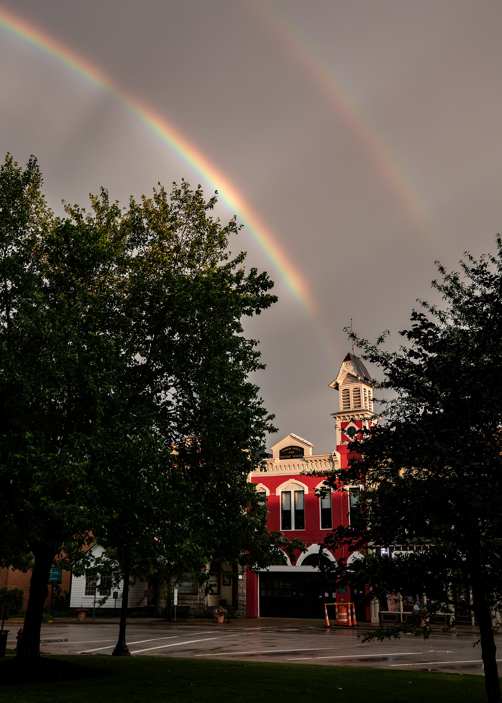
As a storm rolls away and sun breaks through, a double rainbow appears over Medina, Ohio’s old Town Hall and Engine House on Public Square. Dark streaks, anticrepuscular rays, cross the bright rainbow arc.
Returning from a storm interception last night (June 10) and watching the sky from a red traffic signal, I saw a brilliant rainbow glowing against the dark background of clouds. The receding severe thunderstorm was rolling off to the east and the late evening sun was shining through clearing skies in the west. I hoped I could reach Medina’s Public Square before the rainbow faded, since there was the possibility of shooting landmark buildings with a rainbow above. I parked and trotted with my camera across the Square’s green and in light rain, with occasional cloud-crawling lightning overhead, I found my spot. That late sunshine was lighting the bright red top of the city’s old Town Hall and Engine House, dark sky in the background, and — yes! — that brilliant rainbow with a companion arc making the picture. I stood there for a while, shooting the rapidly changing lighting and rainbow intensity and when the sun went away, so did I. I’m very pleased with the resulting picture, which The Medina Gazette published today (at unfortunately low resolution), and I hope it brought a smile to many people who saw it.
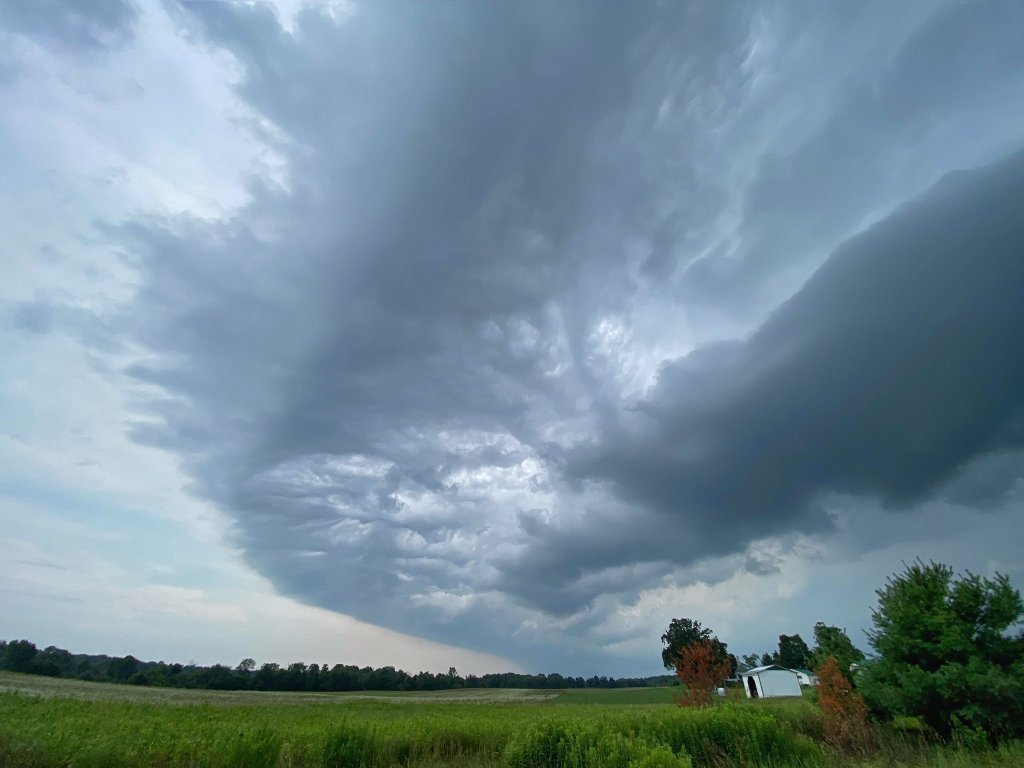
May 10 Shelf Cloud as it clears a tree line to my west. This one was silent until it arrived with 34+ mph winds of very cold air.
It’s “shelfie” season: the time of year when springtime convective weather generates strong thunderstorms and picture-worthy shelf clouds. The popular term for shelf cloud photos, playing upon the term used for smart phone self-portraits or selfies, is shelfie.
May 10 was the first opportunity. I took up position and awaited the storm’s arrival in the parking lot of a public park. As the storm approached I could see only the separated top of the shelf above the treeline; that gave it the appearance of a wall of cloud (not a wall cloud) looming in the distance. The feature came closer and finally made visual separation from the trees and I knew I wasn’t about to be swept away!

Looking like a wall of clouds, the separated top of the approaching shelf cloud is visible above a tree line.
The storm was silent, no thunder, until it drew closer and I could hear the roar of wind in the treetops. A 34 mph peak wind was plenty strong, however, and ushered in a steep temperature drop. I was glad to have a jacket with me.

May 14 Shelf Cloud. You can see the rain curtain in the distance. When the view of the far woods turned white, I knew it was time to get into the car or get very wet!
Another photo-op presented itself with a squall line of severe thunderstorms on May 14. I thought I’d given myself enough time to reach a selected observation point in a city park in Lorain County but as I drove I realized I wouldn’t make it in time. So I bailed to a rural road and found a likely spot: a farmer’s access drive from the road to an wide-open field. I parked, got out of my car, and there it was! There was thunder and lightning with this one so I had some concern; nearby objects were better targets than me so I told myself I was okay. The shelf rolled over my location quickly. Intense rain arrived with 43 mph winds. And then it stopped. The rain and wind simply stopped. That was a very intense, concentrated line that moved along very quickly. A strange experience.

After the Storm. The rain abruptly ended, the wind calmed, and the sky to the west became bright. A strange experience.
