
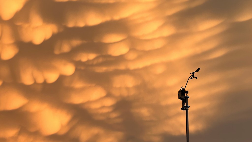
It is unusual for our area to see discrete thunderstorms — individual storms visible against otherwise clear skies — so we miss out on some thrilling sights. The anvil or thunderhead of a strong storm usually happens above a lower cloud layer in our region, hidden from those of us who appreciate such things. On July 20, 2022 a severe thunderstorm rolled right overhead. I’ve rarely, if ever, heard so many cracks of thunder so close by. I was indoors, did not see the mammoth bolts directly above my roof, and was actually getting concerned the house, or my tall flagpole, would be hit. I was close to being afraid of the lightning, and that’s very unusual! The storm passed, as storms do, and I took a peek through a window. To the west the sky was clearing as the clean edge of the thunderstorm moved east but then the thrill: mammatus clouds! Technically, mammatus are not rare phenomena, often hanging from the anvils of thunderstorms, but we rarely see them here for the reasons given above — we rarely see the anvils. The sky was full of them! I grabbed my iPhone (nearest camera) and hurried outside. Though I feared it would end quickly, the display went on til after dark. Here are a few views…


The night of July 5, 2020 brought Earth’s Moon, and planets Jupiter and Saturn together in the night sky in what is known as a conjunction. The bodies
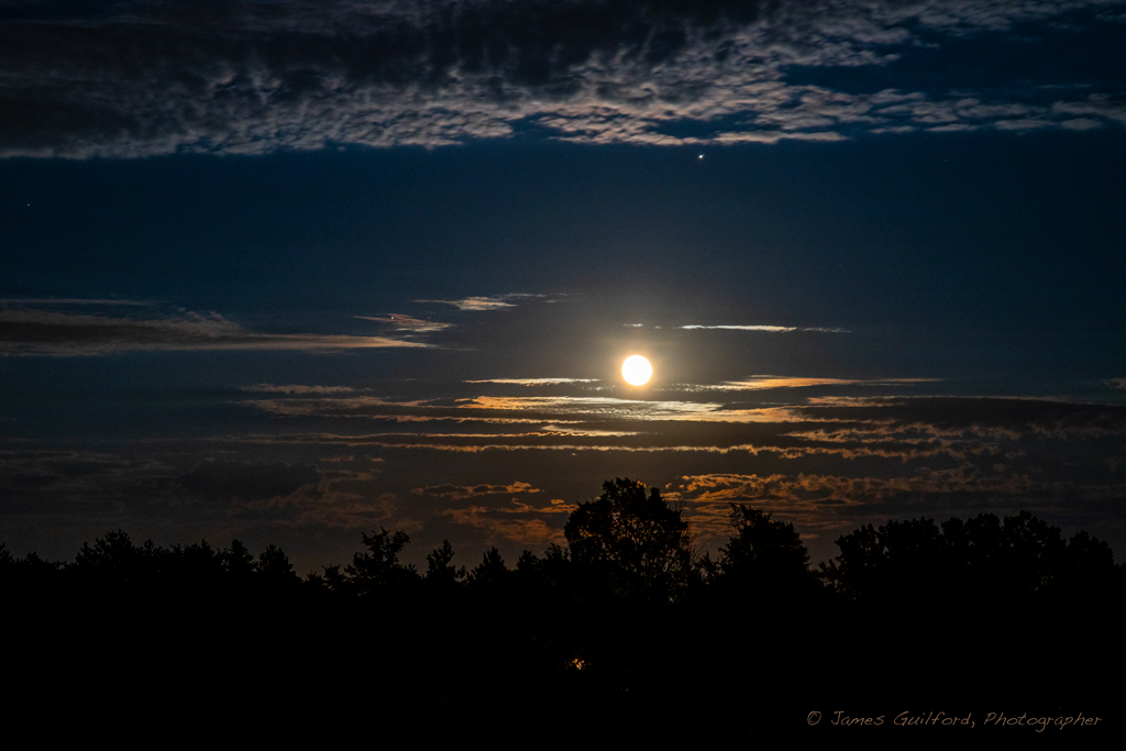
Conjunction of Moon, Jupiter, and Saturn the night of July 5, 2020. Jupiter is the bright “star” above the Moon and just below the clouds, Saturn is the tiny dot next to the cloud to the far left of the Moon. Photo by James Guilford.
didn’t appear all that close together, but because Jupiter is at opposition — its nearest orbital position to Earth — it was particularly bright. Much dimmer Saturn was off at an angle from the Moon forming a sort of triangle, if one drew lines between them. Humans love to connect the dots. At any rate, I went out to the countryside to photograph the gathering, first to a favorite storm viewing site. I shot an assortment of images, watching the motion of a few clouds around the Moon and planets. The clouds, I thought, added to the scene. From my first stop, I headed farther west hoping to capture an imagined scene with Moon and planets reflected in the waters of a small lake. By the time I arrived at the second stop, what I thought would be my prime location, slow-moving clouds had rolled. I stayed on location for quite some time, listening to bullfrogs and shooing mosquitoes, while watching the clouds. After some time I called it quits, packed up the gear, and headed home. I am, however, very pleased with the “consolation prize” seen above.
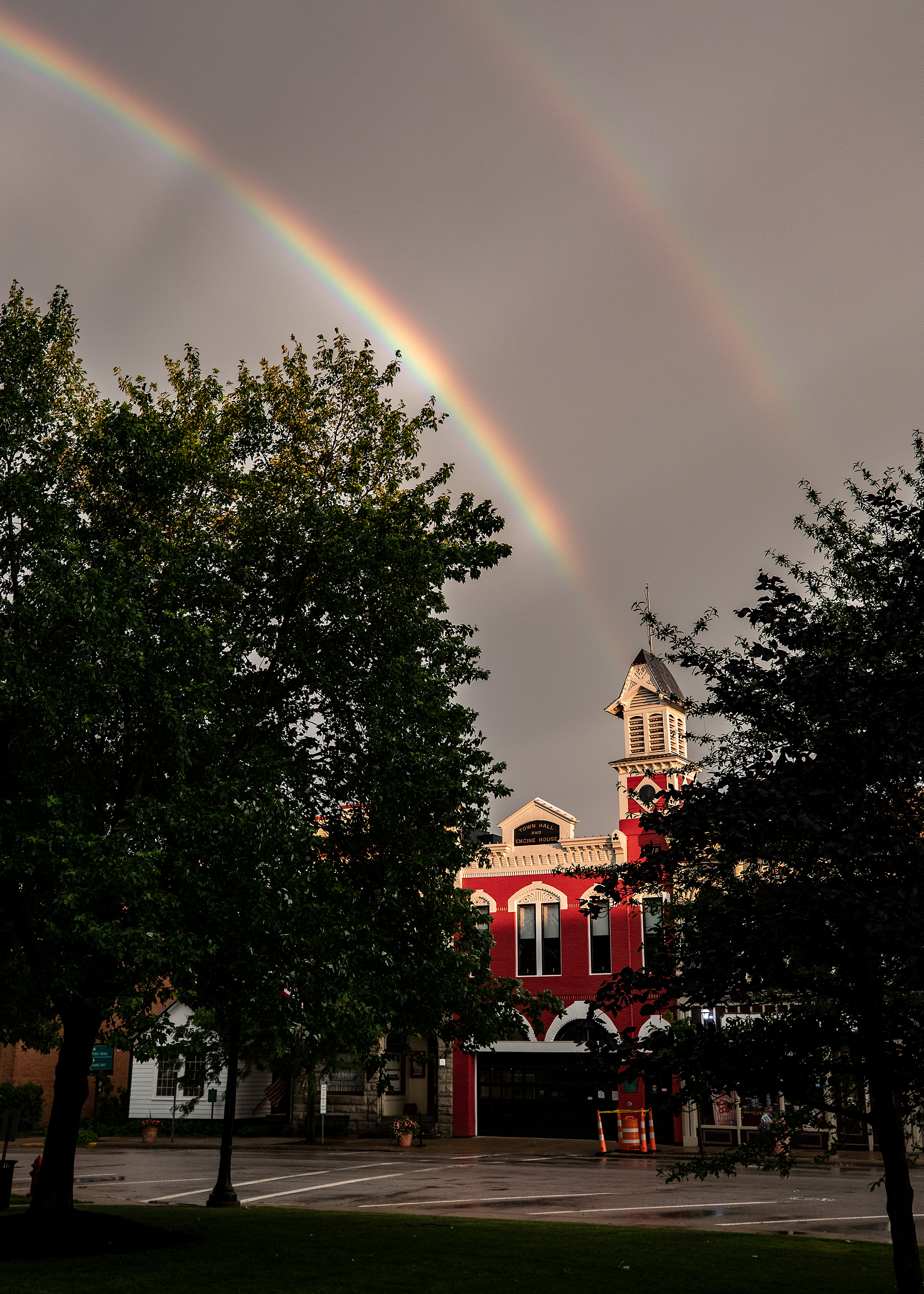
As a storm rolls away and sun breaks through, a double rainbow appears over Medina, Ohio’s old Town Hall and Engine House on Public Square. Dark streaks, anticrepuscular rays, cross the bright rainbow arc.
Returning from a storm interception last night (June 10) and watching the sky from a red traffic signal, I saw a brilliant rainbow glowing against the dark background of clouds. The receding severe thunderstorm was rolling off to the east and the late evening sun was shining through clearing skies in the west. I hoped I could reach Medina’s Public Square before the rainbow faded, since there was the possibility of shooting landmark buildings with a rainbow above. I parked and trotted with my camera across the Square’s green and in light rain, with occasional cloud-crawling lightning overhead, I found my spot. That late sunshine was lighting the bright red top of the city’s old Town Hall and Engine House, dark sky in the background, and — yes! — that brilliant rainbow with a companion arc making the picture. I stood there for a while, shooting the rapidly changing lighting and rainbow intensity and when the sun went away, so did I. I’m very pleased with the resulting picture, which The Medina Gazette published today (at unfortunately low resolution), and I hope it brought a smile to many people who saw it.

Shelf Cloud Panorama
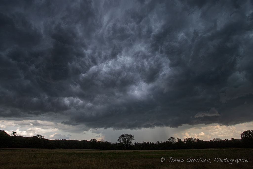
We have had a few days recently when heat and humidity-driven storms have roamed the region. On Tuesday, August 20 we saw a long line of powerful, even severe-warned, storms develop to our west. Though the line appeared to be moving at a leisurely rate, I arrived at one of my favorite observation sites with just enough time to set up before a broad shelf cloud appeared on the horizon.

Storm’s Coming
The leading edge passed over my location and, as is expected with these things, heavy rain immediately followed and I retreated to my car. After a quick splash of intense rain, the precipitation stopped! I got back out of my car and shot a few photos of the areas about to be visited by the storm. One view in particular from behind the shelf cloud: from a spot spared rainfall was this view of the dark clouds overhead, curtains of intense rain drenching the area, and brighter skies being engulfed.
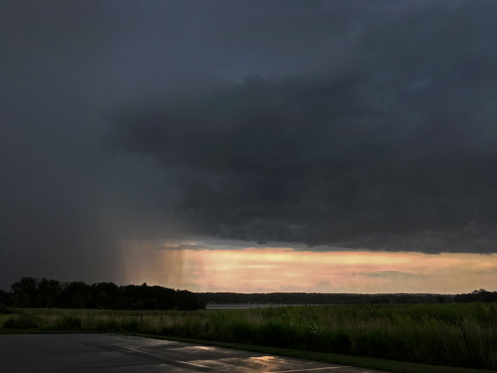
Here Comes the Rain
Ah! Stormy weather!

Shelf cloud photographed July 2, 2019 in central Medina County, Ohio. Note the area of heavy rain to the left, the “clear” area bearing strong winds to the right.
I love shooting shelf clouds — clouds that form a line or arc along the leading edge of a gust front in a thunderstorm. They are awe-inspiring, scary, to me they’re just beautiful in their power rugged symmetry. I’ve looked at clouds from both sides now (apologies to Joni Mitchell) and discovered something at least as impressive; clouds of chaotic shards and pieces, tumultuously flowing together as a mass. I saw this configuration with a severe thunderstorm that dropped a tornado a few weeks ago, and I saw it again today in another severe thunderstorm — after the shelf cloud passed. I still love photographing shelf clouds (called “shelfies”, a twist on self-portrait “selfies”) but…
Tumult. A chaotic storm cloud behind a shelf cloud.

A gust front rolls over open farm land ushering in a cold air mass and heavy rain.
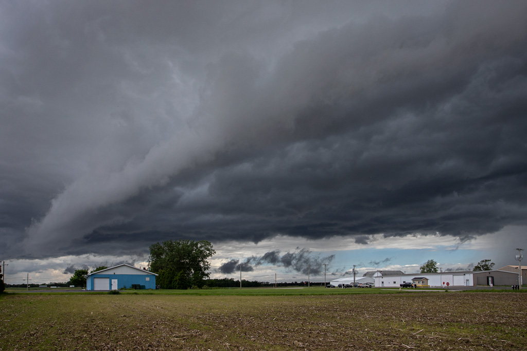
On a visit to Northwest Ohio yesterday (May 30) I stepped outdoors, looked to the west and spied a beautiful sight… the ragged edge of a line of clouds in the distance.
I strolled out, beyond a treeline to get a better look and saw an impressive gust front running ahead of cold air rolling over the area! I quickly shot a series of photos of the scene using my iPhone but realized my big Canon DSLR camera was in the car. I quickly retrieved the Canon and returned to my vantage point.
Seeing how quickly the line was moving, I race-walked seeking a different view and shot a few more photos before rain drops warned me I’d better get to shelter.
Normally I drive miles to intercept phenomena such as this gust front but this time it came to me — a surprise but a convenience — saving me the trip!
A gust front rushes closer ushering in a cold air mass and heavy rain.

Sheldon Marsh with Cirrus Clouds
Photographed and Written: September 16, 2018. Published February 25, 2019.
The weather has been so often uninviting this summer that it was a pleasure to have a nice day Sunday. It was hot but too pretty to stay indoors, so we drove to the Sheldon Marsh Nature Preserve in Huron, on Lake Erie.
It’s migration season for birds but we rarely think of Monarch butterflies … they migrate too! It’s hard to imagine such delicate creatures as butterflies flying hundreds of miles but we have seen seeing them lately heading south. One of the first beautiful things we saw at the preserve was a Monarch picking up nectar from bright yellow flowers along the path.

Monarch Butterfly Fueling up for a Long Flight
We were also delighted to see an American Bald Eagle swooping down over the shallow waters of the marsh trying to catch a fish! As far as I could tell, the eagle missed the fish it was after when I spotted it. Some other visitors told us that they saw the eagle catch a fish but that it got away; it turned out to be a young bird so perhaps it needs to work on its technique! We didn’t even know there was an eagle’s nest at the nature preserve, so this was a real treat. At one point the eagle flew right overhead and that’s when I got my best pictures of it.

Young American Bald Eagle
We watched a Great Egret, though we couldn’t get very close to it. The egrets are brilliant white with dark legs and only a little color: their orange beaks and a tiny greenish patch next to their eyes. They are so bright in sunlight that they are hard to photograph without special camera adjustments. The Great Egrets are sometimes harder to find than Great Blue Herons but are also wonderful to watch and I’ve gotten a few nice pictures of them over the years.

A Great Egret Wades, Looking to Catch Lunch
The main walking path at Sheldon Marsh is not very long but because of wooded areas, the wetland area, and the Lake Erie shoreline, offers plenty of wildlife spotting.
Speaking of spotting, I saw a feather stuck in the bark of a tree along the path! The feather was black with white spots. I don’t know how or why the feather was in that place but I suspect someone found it and put it on the tree. No matter, really, there it was! It turns out the be a wing feather from a Downy Woodpecker – beautiful, small black and white birds that often come to home feeders. I’ve found a Downy feather before but on the ground, not on a tree trunk.

Wing Feather from a Downy Woodpecker
The earliest fall colors are beginning to show up. Among them were some brilliant red leaves from a vine growing on a tree. The afternoon sun was shining through the woods, lighting up the leaves: perhaps my favorite way to look at them!

Sun Shines Through Red Leaves
Among the other things we saw was a pretty Garter Snake – though it was too quick for me to get a picture – and a beautiful little Wood Duck that was quietly paddling around the marsh, just off the trail.

A Male Wood Duck Paddles Shyly in the Marsh
It was a beautiful day but as I said, it was also hot. We were walking slowly and mostly in the shade but we were dripping sweat so we headed home. It was a lovely Sunday afternoon.

Thunderbird. Clouds of the approaching storm spread across the western sky.
A well-defined line of storms was headed our way and looked like a good possibility for shelf cloud photos, so I headed out in the early evening to intercept the storm.

Radar Image of the Approaching Weather – My Location Near Center
Things don’t always work out the way one expects and that may be especially true with weather. The rule proved true but I wasn’t terribly disappointed because of the way things worked out.

Evening Flight. Sunset colors illuminate the clouds. A tiny dot in the upper right-hand area of this image is an airliner on an evening flight.
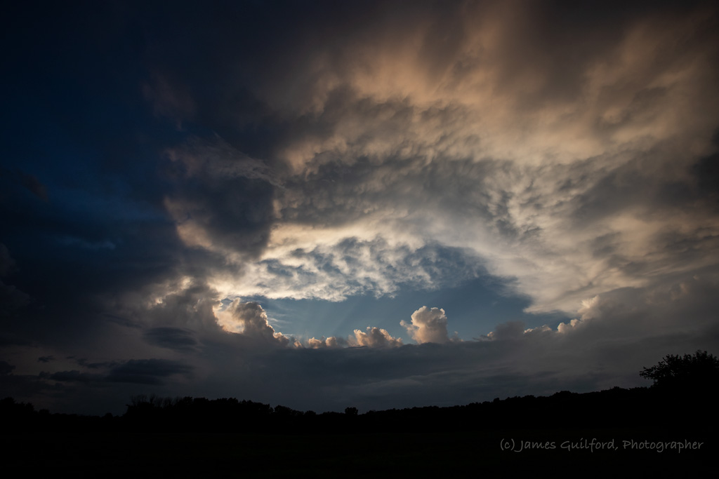
I could hear rumbles of thunder to the north and caught a glimpse of two lightning bolts: one from cloud to ground, the other within a gap in the clouds. But as the line of storms came nearer, the sun was sinking lower reducing the energy driving the weather. While the prospects of strong storm images dimmed, the developing sunset lit the roiling clouds in beautiful and unexpected ways.

Fiery Wave. A swirl of storm clouds lit by sunset.
Storm clouds moved and swirled as they passed across the western sky and rolled overhead, changing from minute to minute. No shelf cloud to be had but the show was wonderful.
Maw of the Storm. Colors fading and clouds closing in.
All but ended, clouds closed in ending the evening’s show, the conclusion of a glorious sunset storm.
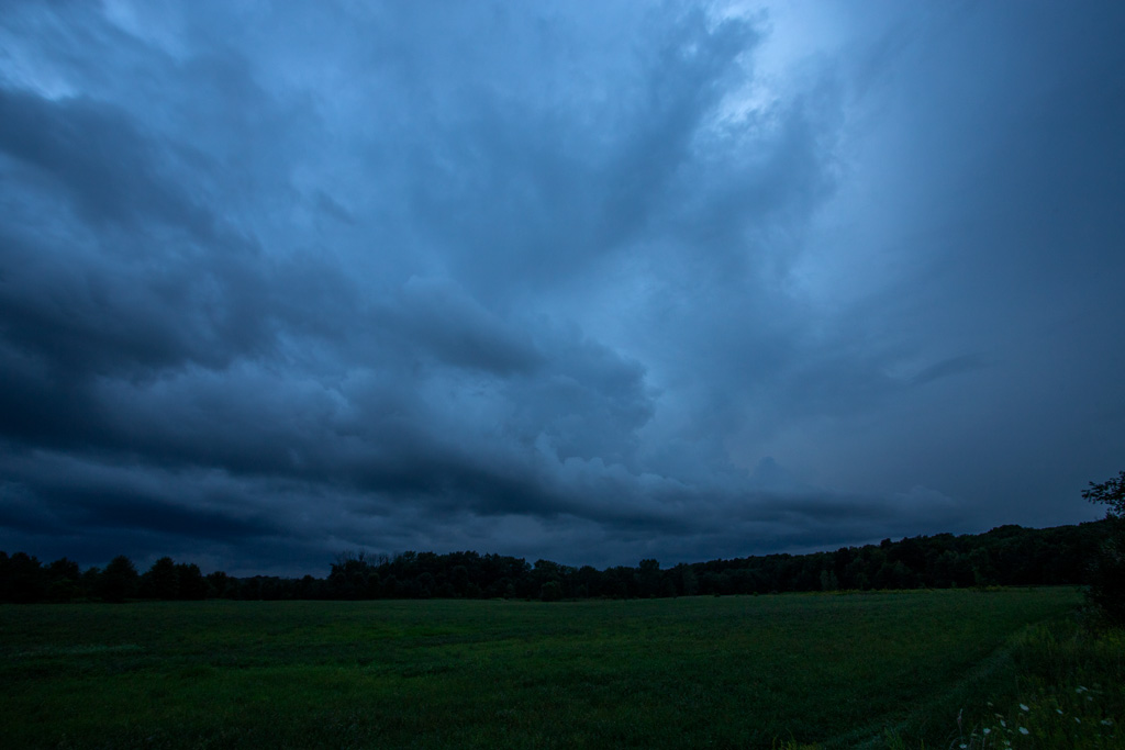
Darkness Falls. Clouds cover the sky and the blue of nightfall tints the scene.
