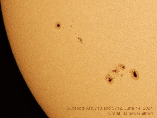
Detail copied from the whole-disk image of Sun, showing sunspots AR3713 and 3712 as they appeared June 14, 2024.
We have not been taking nature walks the way we used to so most photos of animals have been very close to home. I have been photographing the sun lately — maybe especially since the April total solar eclipse. I’ve been interested in Sun at one level or other since my youth. Though I hope to develop the ability to photograph old Sol in Ha or hydrogen-alpha (look it up) exposing chromospheric details in the plasma maelstrom of our nearest star, I remain fascinated with sunspots and the solar photosphere.
Today was another day featuring a cloudy morning and sunny afternoon. This time, however, we experienced excellent seeing for a while — just long enough to record today’s solar portrait. I’m so pleased with the “inset” image that we’re featuring it first — it’s cropped directly from the whole-disk picture. Obviously sunspots AR3713 and AR3712 are dominant features but there is a parade of features visible.
Annotated whole-disk image of the sun as it appeared the afternoon of June 14, 2024.
Doing this the “old-fashioned” way, this image was a single exposure manually selected as best of a larger group of shots. The chosen image is edited to produce the best available picture from the data gathered. Today’s excellent seeing made for an unusually good photo. I’m pretty pleased.
I saved a number of “also-good” exposures and may some day use them in the modern process of stacking sub-frames to create an even better view. Today, however, I’ll just sit back and enjoy what I got.
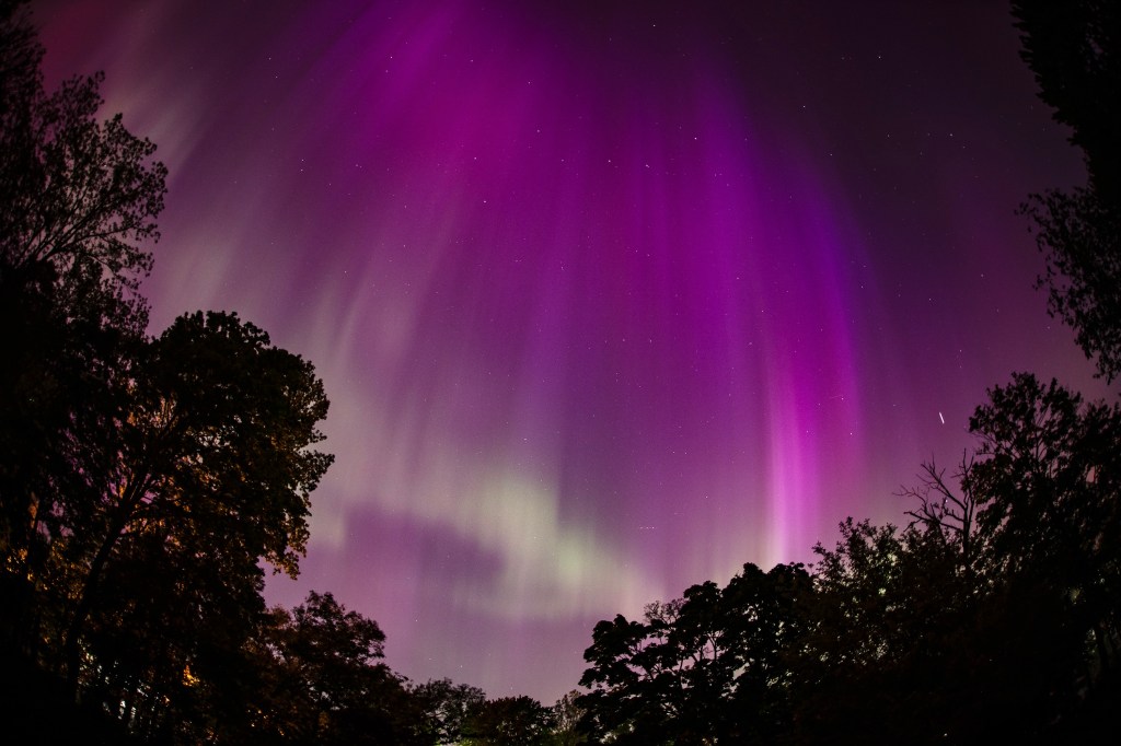
My first DSLR shot of the night turned out to be the most spectacular. This is a view looking northward from the city of Medina, Ohio.
It turned out to be a stronger impact than forecast, and the strongest thus far of this solar activity cycle; the geomagnetic storm of May 10 – 11, 2024 produced auroras (Northern and Southern Lights) visible at night from locations nearly pole to pole.
The forecast of possible aurora prompted me to step outside at about 10 PM (EDT), when twilight had faded, to check the skies. At first I saw what I thought might be clouds but knowing auroras can be feeble, I watched. Sure enough, there was movement in those “clouds”.
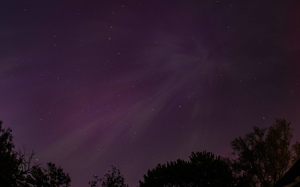
To the unaided eye, the great aurora of May 10 looked like this — streaks of “cloud” with a bit of color. Watching the streaks closely, however, the observer could see them changing in size and shape more rapidly than simple cirrus.
Glancing overhead I saw what I found hard believe — aurora ray features directly overhead … at 41º latitude, a rare sight, indeed! Rushing back indoors, I pulled together camera, fisheye lens, and tripod and headed back out.
My first image of the night was from my iPhone 13. So little effort to see and record such an amazing view! It was exciting to be able to share this with the world in real time via social media!
The aurora still presented itself as cloudy streaks with, perhaps, hints of color. Now also armed with my smartphone, I activated its camera and aimed it at the sky. There on the screen, light amplified by the phone’s electronics, glorious, eye-popping colors filled the sky! I’d never before experienced an aurora like it.
A rare sight indeed is an aurora borealis streaking down from directly overhead at 41 degrees latitude! I’ve never before witnessed such a display.
Only occasionally, during the time I was out, did the aurora’s color become visible to me; apparently being just below the limits of my, and others’ visual perception. Another local observer noted color was more visible shortly before I stepped outside to check on things — the actual peak of the display must have happened as twilight was ending and before 10 p.m.
Colorful curtains lit the northeastern sky as the aurora re-surged from a quieter moment.
I observed and photographed the aurora from shortly after 10:00 until about 11:30 EDT and in that hour or so, the intensity faded and then re-surged before fading away which was my signal to shut down.. I might have stayed out longer but had a commitment for the next day — sleep was needed — so, satisfied I’d seen the phenomenon at its best, I put away the camera gear.
Looking north, find the “Big Dipper” tipped over as if pouring watercolors down on the land. The single dot visible near the center of this picture is the North Star, Polaris. Note how one can find Polaris by looking where the two stars of the dipper’s bowl point.
Knowing it would be all over the news, I submitted my most spectacular shot of the night to the local newspaper — a daily that publishes on Saturday but not Sunday. It was too late for the Saturday edition but the editor gave my photo a three-column, Page 1 spot on Monday.
Our Sun is still in its peak activity period, by some accounts it won’t hit solar maximum until some time in 2025, so there may be more auroras in our near future but this was one for the history books!
Portrait of Cleveland radio personality “Count” John Manolesco, made in the 1970s. Photo by James Guilford
“Cleveland radio has had more than its share of characters. Take “Count” John Manolesco, for example, who hosted a show on news/talk WERE. Manolesco, who claimed to be a physic from Romania, went so far as to perform a live, on-air exorcism.” — Kabir Bhatia, Ideastream.org
I was assigned by a local magazine to shoot photos of Manolesco for a feature article on the Cleveland talk radio personality. I did make the usual photos of him but shot one or two using a low-angle flash — a proven technique to introduce a spooky mood to an image. This is my favorite shot from the job.
John Manolesco was born December 3, 1918 in Timisoaka, Romania, and died January 10, 1983 in Cleveland, Ohio at 65 years of age.
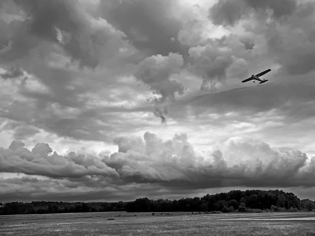
Honorable Mention for my entry entitled “Northward” in the September/October issue of Weatherwise, a respected meteorological journal.
Well would you look at that! One of my pictures received an Honorable Mention in the 2023 Weatherwise Photo Contest! I found out about the honor when the September/October issue arrived today. Weatherwise is the respected meteorological journal featuring “The Power, The Beauty, The Excitement” of weather. You may know I don’t generally enter photo contests. To be selected for even honorable mention from among thousands of entries is, yes, an honor.
After a long absence, we returned to Sandy Ridge Reservation, a notable area for birders in the Lorain Metro Parks System, and were richly rewarded. We spotted and watched a Sand Hill Crane family as they explored the waters’ edge for food: the impressive adults escorted their colt (that’s what the young are called) watching humans watching them from the nearby path. The colt was allowed to explore a bit on its own but the mated pair were never far away. It was thrilling to see the family and a first for me; a wonderful surprise.
As we watched the Sandhill Cranes, Great Egrets, and dragonflies, an American Bald Eagle soared overhead. We could not see the eagle’s nest but behavior told us it was on hunting flights, probably feeding its young in the hidden nest.
A Sandhill Crane colt combs the wetlands for food with one of its parents.A Common Green Darner (Anax junius) in flightBig Foot: This Great Egret was wading the shallow waters of the wetland searching for food, the vivid green patch marking at the base of its beak was particularly striking. Caught mid-stride in this photo, the span of the bird’s toes on its raised foot is impressive!
It is unusual for our area to see discrete thunderstorms — individual storms visible against otherwise clear skies — so we miss out on some thrilling sights. The anvil or thunderhead of a strong storm usually happens above a lower cloud layer in our region, hidden from those of us who appreciate such things. On July 20, 2022 a severe thunderstorm rolled right overhead. I’ve rarely, if ever, heard so many cracks of thunder so close by. I was indoors, did not see the mammoth bolts directly above my roof, and was actually getting concerned the house, or my tall flagpole, would be hit. I was close to being afraid of the lightning, and that’s very unusual! The storm passed, as storms do, and I took a peek through a window. To the west the sky was clearing as the clean edge of the thunderstorm moved east but then the thrill: mammatus clouds! Technically, mammatus are not rare phenomena, often hanging from the anvils of thunderstorms, but we rarely see them here for the reasons given above — we rarely see the anvils. The sky was full of them! I grabbed my iPhone (nearest camera) and hurried outside. Though I feared it would end quickly, the display went on til after dark. Here are a few views…
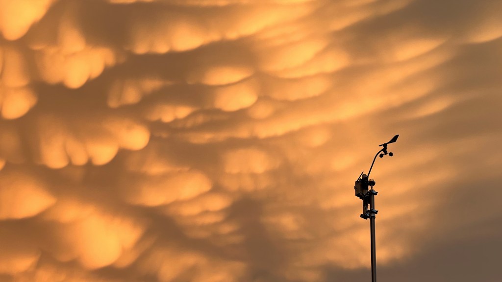
Right after the rain ended, as the storm was moving off, we remained under the anvil where a tremendous display of mammatus clouds was happening. Photo by James GuilfordMammatus clouds hanging beneath the anvil of a retreating thunderstorm, the edge of the anvil visible against blue sky. The clouds form due to extreme turbulence in cloud — discrete pockets of air sinking at high altitude. Photo by James Guilford.And then came sunset! The mammatus-filled sky lit up in sunset colors in a show that persisted through twilight. Photo by James Guilford.Wind vane and anemometer of my weather station silhouetted against a most dramatic sky. Photo by James Guilford.
I stayed up late, anticipating the arrival of a powerful storm system the night of June 13. The MCS (mesoscale convective system) tracked to the south of its predicted path, leaving me at the northern end of storm activity. I thought I was out of luck but saw some lightning and decided to try for some photos. My persistence and resulting sleep deprivation was rewarded. I witnessed several impressive displays of “anvil crawler” lightning — cloud-to-cloud discharges along the cloud base — but missed a couple. At midnight, however, this amazing crawler filled my visual field and the view from the camera. The strong horizontal bolts steal the show but look closer. Even in this reduced-resolution web version of the photo, streaks of lightning reach up and down across the bottom of the storm cloud. I remember seeing the motion of the light, almost like an advertising sign, luminescence racing along those fine lines. The MCS blasted across our region, downing trees and utility poles along its path. Here, the storm passed dropping only a little rain with virtually no wind, allowing me to make this capture (a single exposure). The local newspaper surprised me by using the image — full-frame, in color — huge on their front page! It’s hard for newspapers to hold the finest details in print but the e-version looks pretty good.
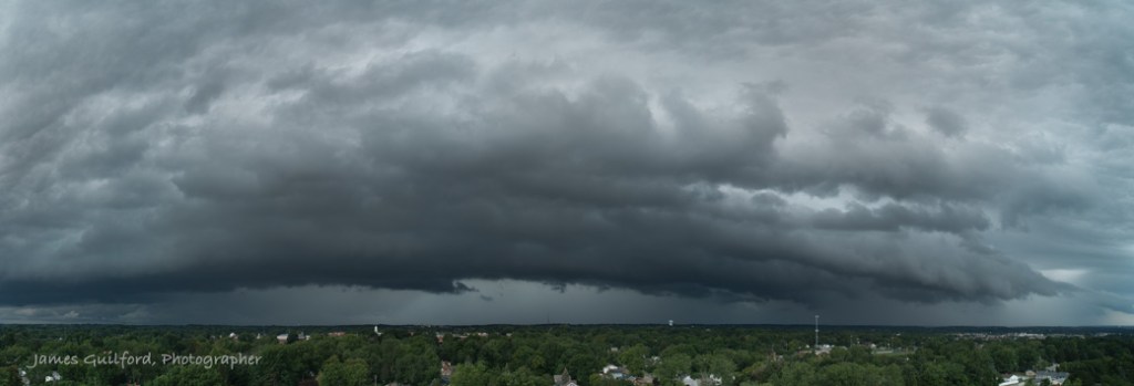
Storm Arrival. A complex shelf cloud developed along the leading edge of a mesoscale convective system (MCS) as it rolled over the city of Medina, Ohio in the middle of the day. Torrential rains followed.
I was able to record the approach of a massive mesoscale convective system (MCS) with its shelf cloud early in the afternoon of August 25 — this panorama I assembled shows most of it. I posted a panning video I shot of the storm and it was discovered by a producer at Accuweather. The cable weather channel requested permission to use the “footage” on-air but I denied the request … I feared their use of my drone video, myself not yet a certified professional drone pilot, would violate FAA regulations. I was later told by a flight instructor that I could have granted permission, even sold the video to a willing buyer, since it was created for recreation and not on assignment or with the intent of commercial use. I still sigh thinking about that one. Mebbie next time!
By the way, I have a lot of experience with this type of weather phenomenon and was even checking radar as the storm approached so I knew when to land to avoid rain and strong winds.








 PhotonStopper